 |
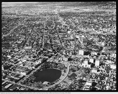
| Aerial view of Westlake / MacArthur Park, 1951. Courtesy of USC Digital Library. |
Much of the changes in the Westlake community during the mid-twentieth century are a result of three major influences: the extension of Wilshire Boulevard through the Westlake community in the preceding era; the urban renewal efforts that took place in Downtown Los Angeles, Bunker Hill; and the enhancement and development of the modern freeway and thoroughfare system in the 1960s. These three physical changes within and around Westlake impacted community life.
Although Wilshire Boulevard was extended to downtown in 1934, its full impact was not immediately felt.[1] Beginning in the 1950s Westlake, Wilshire Boulevard began to take on an increasingly busy urban persona, with high traffic volume. This changed the park from the Champs-Elysees gardenesque motif to a more urban space.[2]
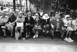
The Community Redevelopment Agency urban renewal efforts in the Bunker Hill in downtown impacted the demographics of the Westlake community unexpectedly. The city redeveloped the “blighted” Bunker Hill, which created a mass exodus of displaced people from Bunker Hill, including many vagrants, many of whom migrated to neighboring Westlake.[3] At the same time, long time residents of Westlake moved to the outlying suburbs. Additionally, the swanky apartment buildings built during the Fashionable Era were repurposed for senior and transient housing on the so-called “Pill Hill.”[4]
 |
| Women enjoying the afternoon in Westlake, 1968. Courtesy of the Los Angeles Public Library. |
Mid-century Los Angeles saw significant changes to roadway and highway infrastructure, which also impacted Westlake. While the changes were made in the name of alleviating congestion, they had serious consequences on community form. With the widening and straightening of Olympic Boulevard, the roadway became heavily used by commuters.[5] Both Olympic and Wilshire Boulevards no longer served to bring tourist to the Westlake destination; instead, they were commuter thoroughfares. Transportation impact on the community was compounded by the development of Route 110 (Harbor Freeway) to the east in 1954 and I-10 (Santa Monica Freeway) to the south in 1966.[6] Combined, these two freeways created boundaries between neighboring communities.
In addition to the physical changes that increased confusion of place, Westlake Park was renamed MacArthur Park in 1942 in honor of General Douglas MacArthur, after World War II.[7]
[1] Fisher, John E., P.E. PTOE. “Transportation Topics and Tales: Milestones in Transportation History in Southern California.” Page 27. Accessed September 9, 2011. http://ladot.lacity.org/pdf/PDF100.pdf
[2] Roderick, Kevin. "Wilshire Boulevard, Grand Concourse of Los Angeles." Page 8. Los Angeles: Angel City Press.
[3] Strawn, James. "Whose Park: An Architectural History of Westlake-MacArthur Park." Page 69. Acessed September 2, 2011. http://search.proquest.com/docview/193342302?accountid=14749.[4]
[5] Fisher, 29
[6] Faigin, Daniel P. “California Highways – Routes 105 through 112.” Last modified September 14, 2011. http://www.cahighways.org/105-112.html#110
[7] Strawn, 61


